South coast · 39.9372° N, 3.9596° E
Cala Galdana by boat
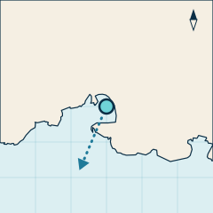
Cala Galdana sits on the south coast of Menorca. Its mouth opens to the southwest (203°), so the wind that blows straight in is the llebeig. It is right next to the port of Cala Galdana: under 5 min away by boat. OpenStreetMap lists the beach as sand.
Boat forecast
After 6 pm we show tomorrow.
- Todaytramuntana 12 knwaves 0.3 m
- Tomorrowgregal 7 knwaves 0.2 m
- Wed 4gregal 7 knwaves 0.2 m
Today, with tramuntana at 12 knots, it is sheltered.
Best day in the next 7: today.
All Menorca coves today, by wind
Forecast for guidance only. Before you go, check the AEMET marine forecast and ask your rental company. Weather data: Open-Meteo.com (CC BY 4.0). Waves: ICON Wave, German Weather Service (DWD).
Getting there by boat
The distances in the quick facts are by sea from the six reference ports, worked out on the OpenStreetMap coastline and rounded to half a mile. Times are a rough guide: a steady 15 knots, with no stops and calm water.
From Cala Galdana and Cala en Bosch it is a short hop of half an hour or less, the easiest options if you want to spend the day at the cove rather than at the helm.
Maó, Fornells and Addaia are more than 20 miles away. From Addaia, the round trip adds up to about 4 h 40 min at 15 knots, so it only makes sense as a day exploring the coast.
If you go out on a navigation licence (licencia de navegación), remember it only lets you go 2 miles from a port, marina or sheltered spot, and the rental company sets the area you can use. More in our guide to hiring a boat without a licence in 2027.
Which wind suits it
Good choice with tramuntana (N), gregal (NE) and llevant (E). These blow off the land or from behind the cove, so the mouth stays sheltered.
Avoid it with migjorn (S), llebeig (SW) and ponent (W). They blow straight in and push the swell into the cove, which makes anchoring and swimming harder.
With xaloc (SE) and mestral (NW), which come from the side, shelter is partial and depends on how hard it blows.
If the llebeig is blowing, the nearest sheltered alternatives are Cala del Pilar (approx. 23.5 nm) or Cala Mesquida (approx. 26.5 nm).
The orientation comes from the shape of the coastline in OpenStreetMap: it is a reference, not a forecast. Before you go, check the AEMET marine forecast and ask your rental company. You can compare coves on the wind and port map.
Anchoring and seagrass
In the Balearic Islands anchoring on Posidonia seagrass is generally prohibited (article 7 of Decree 25/2018 of the Balearic Government). In practice: drop anchor on sand, and where there is an authorised mooring field, use a buoy.
This page does not show the type of seabed yet: we will only publish it with an official source. Until then, look carefully at the bottom before you anchor. More in our guide to anchoring without harming the seagrass.
Nearby coves and how they differ
- Mitjaneta, approx. 1 nm by sea. With mestral (NW) it is better sheltered than Cala Galdana; with llevant (E), less so. From Cala Galdana: approx. 1 nm (approx. 1 nm further).
- Cala Mitjana, approx. 1 nm by sea. With mestral (NW) it is better sheltered than Cala Galdana; with llevant (E), less so. From Cala Galdana: approx. 1 nm (approx. 1 nm further).
- Cala Macarelleta, approx. 1.5 nm by sea. With mestral (NW) it is better sheltered than Cala Galdana; with llevant (E), less so. From Cala Galdana: approx. 1.5 nm (approx. 1 nm further).
Boats to get here
Hire boats leaving 12 miles or less from Cala Galdana, nearest first.
Sources
- Name, coordinates and beach type: OpenStreetMap (way/113605773), © OpenStreetMap contributors (ODbL).
- Sea distances and orientation: our own calculation on the OpenStreetMap coastline (25 metre grid, expected error up to 8%). How we work it out
- Nearby coves by sea: same calculation, from 24 October 2026.
- Data checked on 23 October 2026.
For guidance only. This does not replace the regulations, the Harbour Master (Capitanía Marítima) or the instructions of your rental company. Always check the forecast before heading out.